| Project Home | About the Scans | Browse Gallery | Image Map | Support Data | Resources | Ephemeris |
Featured Image - 06/23/2009
Sinus Amoris
Editor's note: After a lengthy and comprehensive development and testing period, the original webmap interface for the scan products from the Apollo Digital Image Archive Project has been officially retired and replaced with a brand-new WMS-based user interface. Our goals for this major redesign were simple. First, we wanted to improve the user interface by making the Apollo Digital Image Archive website faster and more responsive. Secondly, we wanted to make it easier for users to rapidly find specific and useful images. You now have much greater control over selecting the Apollo metric photographs that you want to view, including the selection of individual Apollo J-mission lunar orbital ground tracks, the display of named lunar features, and a selection of relevant lunar basemaps. Finally, we wanted to develop a robust web infrastructure that will also support one of our other projects - the Lunar Reconnaissance Orbiter Camera (LROC). A version of this new Apollo interface will actually serve as the distribution framework for the LROC Narrow Angle Camera images to the outside professional lunar science community and the general public once LROC NAC images have been released to the NASA Planetary Data System. If you are curious as to how the LROC team intends to let users easily browse LROC NAC data, then hopefully this new Apollo Digital Image Archive website will help to illustrate how that will happen. You can access the new webmap interface or use the browse gallery, which includes oblique views that aren't shown on the webmap. With LRO safely in lunar orbit, the people behind the Apollo Digital Image Archive are eager to continue sharing more exciting views of the lunar frontier in the months and years to come.
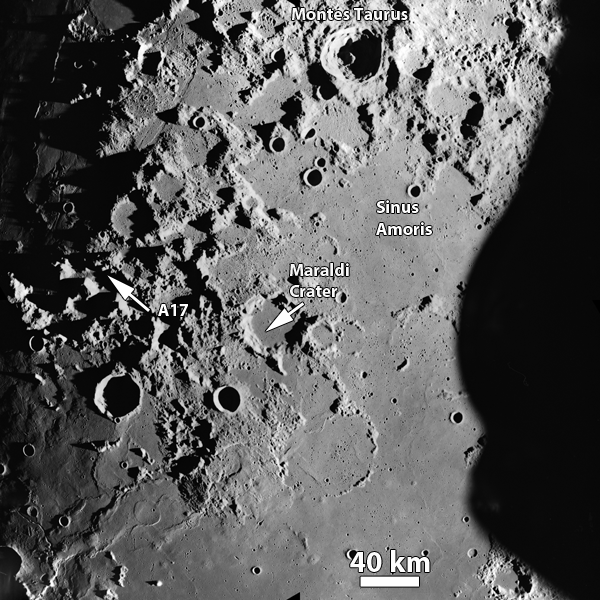
Apollo 17 Command Module Pilot Ron Evans took this photograph during revolution 2 of the Apollo 17 mission, as the CSM America approached the Apollo 17 landing site (still in shadow on the left side of the image) in the Taurus-Littrow valley. You can see here an interesting mixture of ancient highlands (the southern Montes Taurus, in the upper part of the image) and younger mare units. This mare, named Sinus Amoris, is connected to northeast Mare Tranquillitatis. You can see numerous craters and structural features related to this region's proximity to three major basins (Crisium to the east, Serenitatis to the west, and Imbrium) that have been flooded by mare lava flows. This area is noted for the quasi-rectilinear (i.e., vaguely square-like) pattern noticeable under low-Sun illumination conditions in some of the places where the mare meet the highlands, especially in the north. It is thought by some lunar scientists that these distinctive northeastern and northwestern trending structural features are a result of faulting caused by the formation of the giant Imbrium impact basin to the west. The topography and high-resolution imagery returned by the recently-launched Lunar Reconnaissance Orbiter will help to clarify the complex stratigraphic relationships in this and other lunar regions with complicated geology as a prelude to the future extended human geological exploration of the lunar surface.
Figure 1. Annotated view of Sinus Amoris,
east of the Apollo 17 landing site and northeast of Mare
Tranquillitatis (Apollo Image AS17-M-0305 [NASA/JSC/Arizona State University]).
References:
Apollo Over the Moon: A View from Orbit (1978) H. Masursky,
G. W. Colton, F. El-baz, eds. NASA SP-362.

|
|
Space Exploration Resources |
|
 LPI LPI
|
